

Technical climbing info
- Mountain: Mount Adams
- Elevation: 12,281′
- Route: Adams Glacier
- Length: 5,000′
- Grade: III, AI2-3
The call to adventure
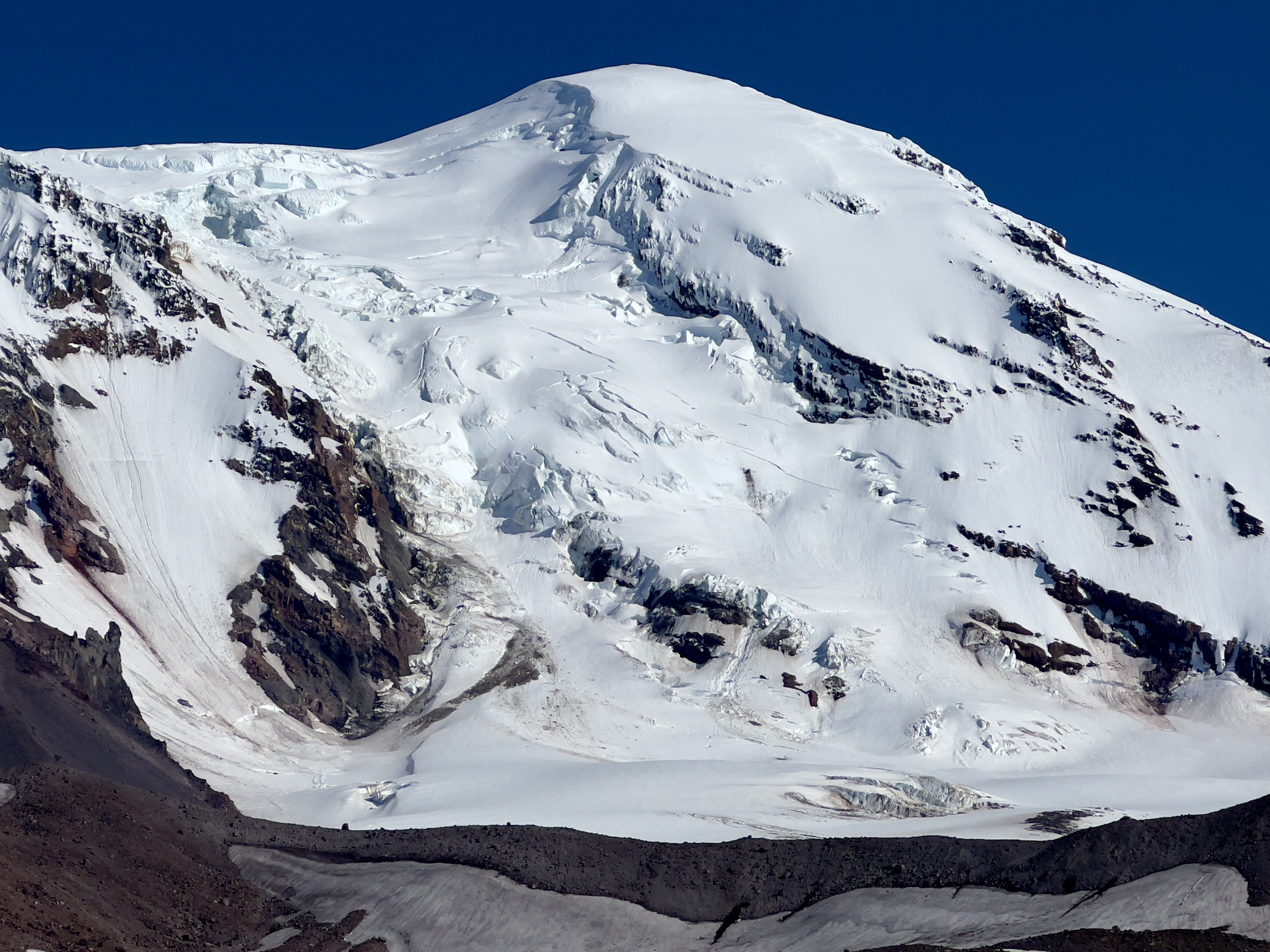
Mount Adams seems to be the big mountain that has kept out of the public eye of most Pacific Northwest residents. For budding mountaineers though, its South Spur route is nearly a “must do” on the path to Mount Rainier and the likes. I didn’t follow that path though, and as my climbing path evolved, my heart became set that my first climb of Adams would be via the mighty Adams Glacier.
Annually since 2019, Jessica and I have humping our gear up the Killen Creek trail hoping to find the route in favorable conditions. With the overheard objective hazard that this glacier presents, neither Jessica nor I wanted conditions to be anything less than stellar. We were looking for a good snow fill, extremely low avalanche hazard, and cool temperatures. Those variables finally looked like they lined up for a splitter window on the July 4th weekend of 2022.
Jess and I packed our bags- one overnight kit and 5 pickets. 5 pickets is a ton in PNW style, but is far less than South American style, which I have become a fan of as well. We’d also be bringing up our new Samaya Ultra tent to test before using deep in the alpine. (Maybe one day I’ll do a review of it, but in short, it proved to be pretty sexy.)
The first crux was the road
I hadn’t heard anything about the north side of Adams for all of 2022, so I gave a call to the Gifford rangers to see if any beta was available. They had apparently not been up there, but relayed that the Killen Creek trailhead was “possibly accessible”.
The road in proved to be “possibly accessible” indeed. We found ourselves getting waved down by a camper at the Divide Camp parking, we pulled over. His truck was wheel-deep in the mud, and we spent 30 minutes digging and shoving branches under his tires with no avail. Eventually we used our inReach contact a family member to get some real help for him, offered him water and food for the wait, and wished him our best.
Not too far later, our car also got stuck, this time in the snow, and Jessica proved to be a Montreal native and got us out. We parked on the side of the road, about 3 miles from the trailhead. A walk would be ahead of us.
The karma points from helping the previous stuck driver seemed to immediately repay! We heard the engine of an overlander SUV on the road behind us and stuck out our thumbs for a ride. The couple driving enthusiastically pulled over and picked us up. It turned out they also winched out the stuck truck-guy a few minutes before.
✅ Helped dig a truck out of mud
✅ Successfully hitchhiked to trailhead
✅ Real Cascades adventure confirmed
The approach was fairly moderate, mostly covered in snow. We navigated almost solely with GPS, plunking down at the meadows camp (aka “high camp”), far below the Adams Glacier. With the shenanigans on the road, it was already getting late. We plotted out our line up the route, melted snow, and called it a night.

4000′ AHEAD
2AM, the alarm rang. I has already been awake for an hour, my body always wakes me up early. We ate breakfast, booted up, and headed off into the night. The sun started to rise as we approached the face; it was cold, a good sign. I checked our elevation, over 4000’ of climbing towered above us. Wow.


We targeted the path we had drawn, orienting ourselves with the ice flow covered cliffs above us. The climbing started as just steep walking, but eventually turned into low daggering. It was staggering how much larger every feature was up close than they looked like from our camp. Every little crack in the glacier I glossed over in my route photo was absolutely massive. The seracs were as awe inspiring as they were intimidating.
Spindrift beautifully blew over the terrain features above us. I quickly realized that seeing spindrift on features above meant that there was no hiding crevasses in the terrain above us. I used that to navigate our path upwards.
We moved fairly quickly up towards the upper half of the route.


The first complexity
The problem crossing a crevasse without a bridge is that there are simultaneously zero options and infinite options at the same time.
The snow was in great condition so far, and the crevasses seemed to be easily navigable, fairly in line with what we could see from below. We had been making great time, and aside from our legs burning, we felt like we’d probably be at the summit by noon. Then came the first crevasses crossing with no bridge. Huh.
The problem crossing a crevasse without a bridge is that there are simultaneously zero options and infinite options at the same time. I narrowed it down to 3 factors that I wanted to see in a crossing. First, I needed a section with a strong lip that could hold a deadman anchor. Second, I needed a section that had a reasonable crossing within the crevasse- one that wouldn’t require any jumps or Vertical Limit type moves. Last, I would need an exit that looked reasonable to climb out of with a self belay. After much pacing, I located the best spot.
What came to my mind as I set up our rap station was the commitment to complete this climb if we went any more forward from here was real. There would be no clear way back. To continue, or to retreat? I belayed Jess in while thinking about it. We decided to continue.


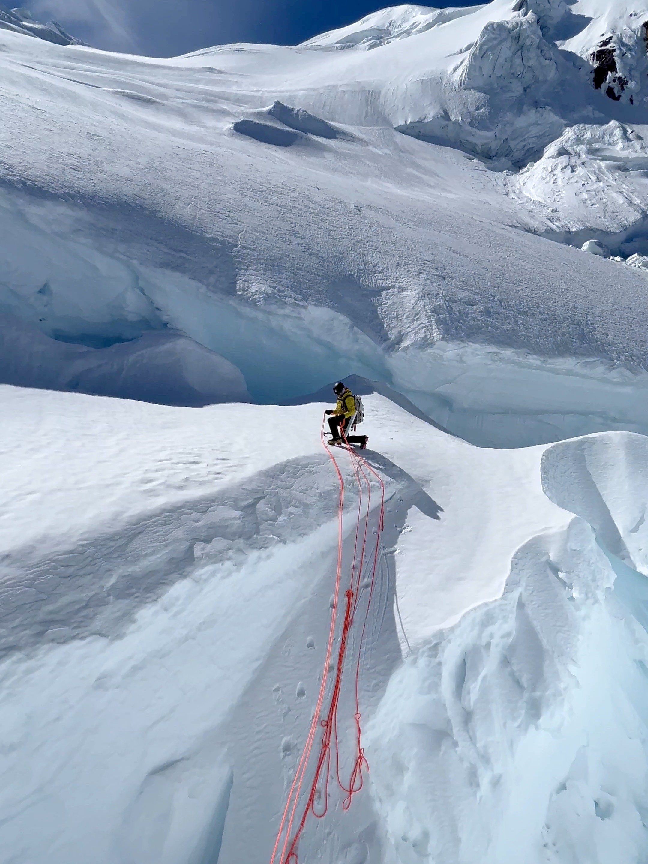
Rapping into the crevasse, note the clean rope saddlebags. And then success! ..don’t mind the messy rope.
We set up the rappels. I (gently) bounce tested the deadman with a backup anchor. Okay, that will do. I kissed Jessica and waived bye-bye to the gear we’d be leaving behind. I rapped in, made an exciting little move across, climbed out via a moderate snow ramp, and put Jess on belay. She followed. Easy enough.
A decision point
We had burned a lot of time determining exactly how to cross the previous crevasse. I hoped that that would be the last complexity. We had two clear options ahead. To the left, we could cross under an extremely large searc formation, and then have an unobstructed direct line to the summit plateau. It would be an extremely exposed few minutes of moving quickly through a debris field. Alternatively, we could go straight up, and take our chances with navigating the crevasses ahead.
We figured we could manage crevasse danger better than we could manage the serac danger. So we chose to go up.


The second complexity
We scurried away from the serac dangers that were clearly present overhead, and beelined to what would almost certainly be another crevasse challenge. It was, indeed, another crevasse challenge. There were a few bridges that were far too thin to even consider walking over. We traversed back and forth along the crevasse searching for a way over. Nothing looked good.
We determined that we could either cross over a series of thinly bonded blocks, or climb in the seracs on the ridge far to the right. We had seen those seracs release earlier in the day, so that seemed like a bad decision. I paced back and forth along the crevasse looking for a crossing. I even descended into the crevasse only to find terribly bonded snow blocks and retreated back out.

We finally decided on what would be the absolute worst crevasse crossing I’ve done to date. It was a series of 4 thinly bonded blocks that looked like they would blow with a mean look. I had to remind myself of how heavy glacial ice really is, and that my weight would probably/hopefully be irrelevant to them.
I remembered an RMI guide on a Kautz climb I was on years before army crawl across a snow bridge. I figured after I did a few moves to lift myself onto the first block, I would use the army crawl technique. After a ton of testing, I pulled myself up gently onto the blocks and crawled my way across, from one block to another. When I finally could reach a stable surface above me, I pounded in a picket and climbed the absolute fastest I could get above all of that. Phew. Jess, you’re on belay! She made quick work of it.
The final complexities
We had spent far too much time with glacier shenanigans, and looking ahead now, we did not know what to expect. The photos we took from the base were not clear for the higher mountain, but from where we stood, it looked “okay”.
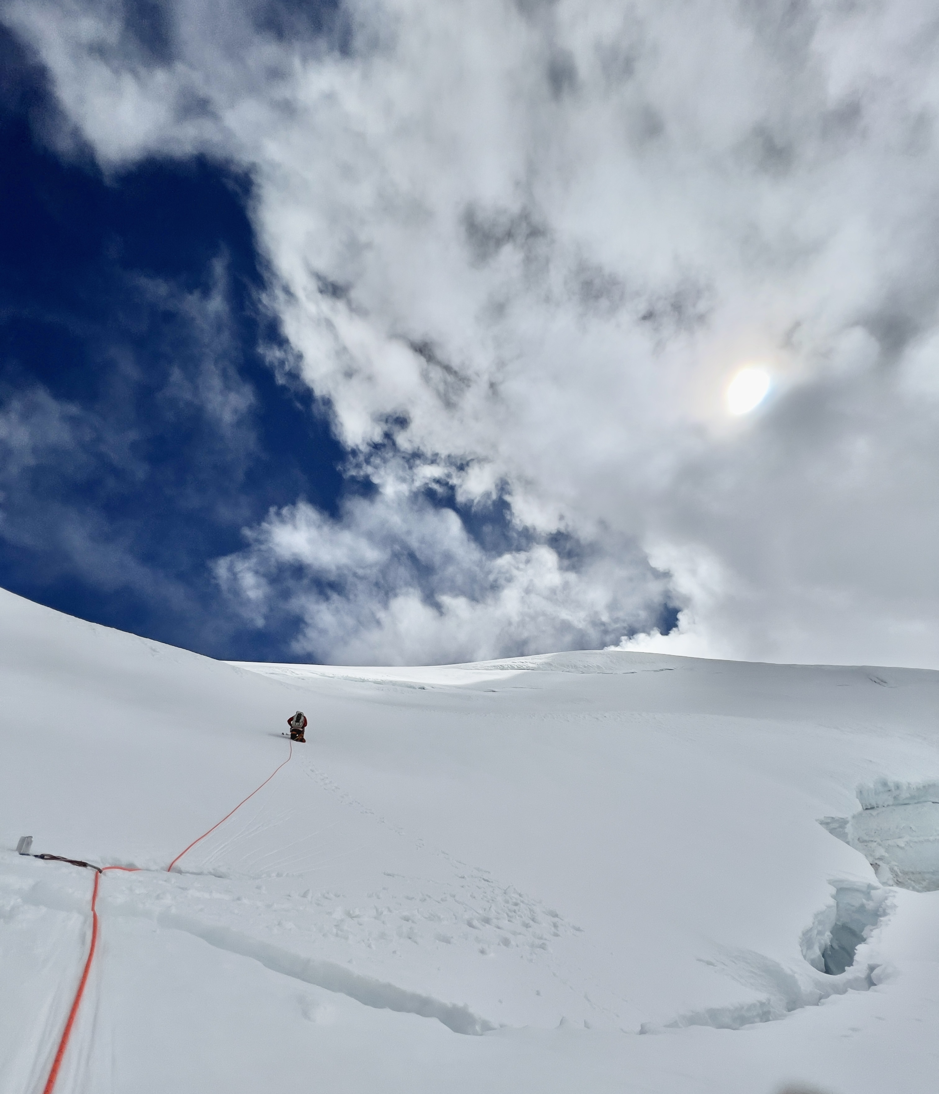
We could see and feel the weather coming down on us. A massive looming mushroom shaped cloud began to make its presence known, and we could feel the wind blowing harder and harder. The next two crevasse crossings were fairly straightforward snow bridges, albeit thinner than I would like. We would employ a belay and army crawl across both, really trying to go as quick as possible while still being delicate.


By the time we finally saw our final slope to the summit plateau, I didn’t fully believe that the shenanigans were over. Thankfully, the mountain proved me wrong in our favor. The low daggering eased into a walk, and the gaping crevasses turned into modest tears in the snow. The weather, however, had different plans. We found ourselves in a dense fog and high winds. “Are we in a storm? This mountain just keeps on giving!“, yelled Jess from behind.
Route completed
It was later than we’d like in the day, and the weather was bad enough that we could only barely see or hear each other. We had reached the 11,800’ mark, which was where we determined earlier that we could traverse to our North Ridge decent route. In classic “Chris and Jessica style”, we opted to skip the summit and head directly to the descent.
We used almost pure GPS navigation in the heinous weather, with only a few moments of cleanings to visually set our bearings. When we finally could visually confirm we were actually on the ridge, we felt a sigh of relief. It was a slow going process in the bad weather though, and our descent look much longer than we expected. The weather did end up clearing eventually, and I tried to get the most enjoyment out of the North Ridge as possible. It was a long day, but it was one that offered an immense amount of natural beauty.

We got back to our tent with headlamps on, and decided there was no way we wanted to hike back to the car and drive 4 hours back to Seattle. We pinged our work colleagues that we’d be taking a “day off”, melted snow while sharing a meal of a single cheese stick and a snack sized bag of goldfish crackers, and crashed in our tent.
In conclusion…
In conclusion to this whole story that I feel like I wrote too much about, I left this climb with a lot of psych and gratitude. I am glad that it was my first climb on the formidable yet humble Mount Adams. I am glad that we waited for the right conditions for a route defined by objective hazards. I am glad that it was done on a year where Mother Nature asked us to spend time in the desert rather than the alpine.
I think this route is deserving to be on to-do lists. Would I climb it again? Probably not. Would I consider that I “did Adams?”. Definitely not. Did I drive away fulfilled? Absolutely so.

A bit of beta


I wouldn’t expect anybody to really ever take the exact same line up this route, as the glacier is essentially a living and changing being on it’s own. However, maybe this will help a bit.
We did find that given a few minutes of exposure to the seracs, a climber would be able to skip a significant amount of the difficulties. From reading online, it seems that many people take this option. It’s hard to say which is the better decision, and it would be hard to gauge even when on the ground, it seems.
This blog post has received a significant amount of traffic since its creation. Please note that while the difficulty and technical grade is modest, this route is committing and threatened by a significant amount of overhead hazard. Insist on cold weather and low avalanche danger. We spent 3 years analyzing conditions and turned away 2 times before finding it in the reasonably safe conditions you’ve read about above. For reference, the freezing level when we climbed this was 8,200′.
Up next, another epic cascade volcano CLASSIC IN MY BOOK

Mt. Hood, Cathedral Ridge
There are really 2 ways to climb the Cathedral Ridge. Either approached by Lolo Pass, all the way from the far northwest flank of the mountain. While scenic and pure, it requires climbers to somehow get back to their car when descending to Timberline. Alternatively, it can be approached from the good ole south side. It…
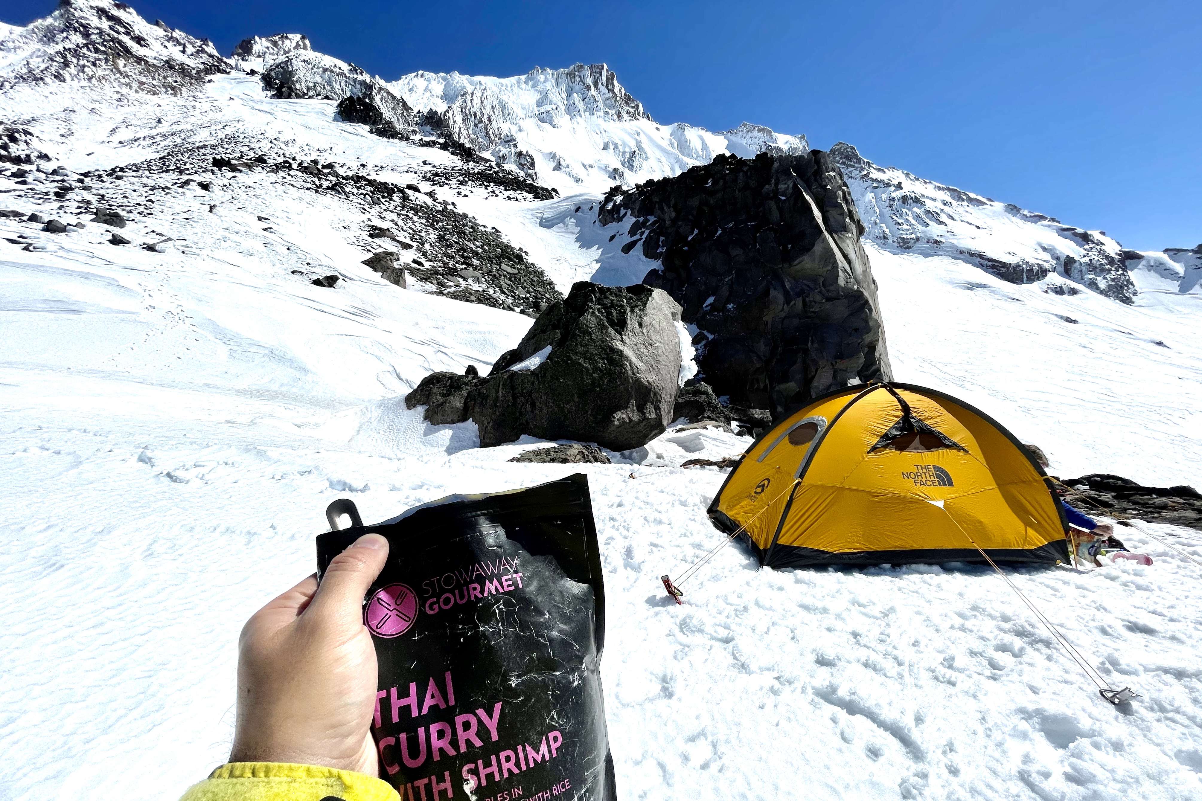
Big thanks to Stowaway Gormet for supporting my 2021 climbing season! This is a brand that I fell in love with prior to my official partnership with them. These are by far the absolute best backcountry meals I’ve ever had, and I’m psyched to be eating them all year! Check out my meal reviews here!